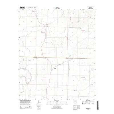
2014 Map of Ouachita
USGS Topo · Published 2014About this map
The Quachita River winds through the southwestern corner of this Dallas and Ouachita County landscape, where the river valley gives way to a network of creeks and low-lying wetlands. The small settlements of Ouachita and Smead serve as the primary human hubs in an area dominated by timber and water. In the northern reaches, the Brazeale Cem sits near the headwaters of Hall Cr, a vital point for genealogists tracing early families in the region. The map reveals a complex aquatic system, featuring the oxbow-like Georgia Lake and Utley Lake alongside smaller bodies like Shell Lake and Bacon Lake. This drainage pattern, including Tulip Creek and Brushy Cr, illustrates the heavy influence of the river's floodplain on the local road network, such as Quachita 36 Rd, which connects these disparate rural communities.
Find a feature on this map
47 named features on this map. Tap any name to fly to it.
Don’t see what you’re looking for? This feature index may not catch every label — zoom into the map to look around manually.
Map Details
Editions of this 2014 Ouachita Map
This is the sole edition of this map. No revisions or reprints were ever made.
Other maps of this area
1903 · Camden
USGS Topo · 1:125,000

1953 · El Dorado
USGS Topo · 1:250,000
1957 · El Dorado
USGS Topo · 1:250,000
1958 · El Dorado
USGS Topo · 1:250,000
1960 · El Dorado
USGS Topo · 1:250,000
1971 · Tates Bluff
USGS Topo · 1:24,000
1971 · Sparkman
USGS Topo · 1:24,000
1971 · Ouachita
USGS Topo · 1:24,000
1971 · Harmony Grove
USGS Topo · 1:24,000
1971 · Sparkman NW
USGS Topo · 1:24,000