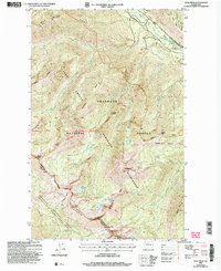
2002 Map of Oval Peak
USGS Topo · Published 2006About this map
Oval Peak stands as a central topographic anchor within the Lake Chelan Sawtooth Wilderness, where the high-altitude divide separates the drainages of the Okanogan National Forest and the Wenatchee National Forest. This 2002 update of a 1968 survey reveals a landscape defined by sharp alpine crests and high-mountain basins, including East Oval Lake and Middle Oval Lake. The terrain is characterized by massive features like Sawtooth Ridge and War Creek Ridge, which funnel water into the Twisp River system via War Creek and Eagle Creek. For those following historical paths, the Horseshoe Basin Trail and the presence of a Trail Camp illustrate the long-standing recreational and access networks through Eagle Pass and Fish Creek Pass. This data serves as a precise record of the administrative boundaries between Chelan and Okanogan Counties during the early 21st century.
Find a feature on this map
50 named features on this map. Tap any name to fly to it.
Don’t see what you’re looking for? This feature index may not catch every label — zoom into the map to look around manually.
Map Details
Editions of this 2002 Oval Peak Map
This is the sole edition of this map. No revisions or reprints were ever made.
Other maps of this area

1899 · Methow
USGS Topo · 1:125,000

1901 · Methow
USGS Topo · 1:125,000

1902 · Stehekin
USGS Topo · 1:125,000

1904 · Stehekin
USGS Topo · 1:125,000

1944 · Lucerne
USGS Topo · 1:62,500

1949 · Lucerne
USGS Topo · 1:62,500

1955 · Concrete
USGS Topo · 1:250,000

1958 · Concrete
USGS Topo · 1:250,000

1962 · Concrete
USGS Topo · 1:250,000
1969 · Midnight Mtn.
USGS Topo · 1:24,000