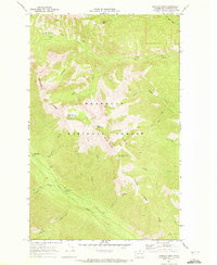
1969 Map of Midnight Mtn.
USGS Topo · Published 1972About this map
Okanogan National Forest land defines the high-altitude landscape of this 1969 survey, where the drainages of Wolf Creek and the Twisp River carve deep valleys between massive peaks. The terrain is characterized by its glacial geography, featuring Abernathy Ridge, Midnight Mountain, and the curious naming of Three A M Mtn. This map captures the region's wilderness character just as modern recreation infrastructure began to settle in, shown by the placement of Poplar Flat Campground and Mystery Campground along the riverbanks.
Find a feature on this map
25 named features on this map. Tap any name to fly to it.
Don’t see what you’re looking for? This feature index may not catch every label — zoom into the map to look around manually.
Map Details
Editions of this 1969 Midnight Mtn. Map
2 editions found
Other maps of this area

1899 · Methow
USGS Topo · 1:125,000

1901 · Methow
USGS Topo · 1:125,000

1902 · Stehekin
USGS Topo · 1:125,000

1904 · Stehekin
USGS Topo · 1:125,000

1920 · Slate Pass
USGS Topo · 1:125,000

1955 · Concrete
USGS Topo · 1:250,000

1958 · Concrete
USGS Topo · 1:250,000

1962 · Concrete
USGS Topo · 1:250,000

1962 · Mazama
USGS Topo · 1:62,500

1963 · Silver Star Mtn.
USGS Topo · 1:24,000