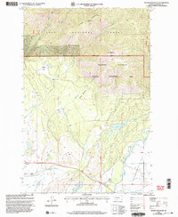
1999 Map of Ovando Mountain
USGS Topo · Published 2003About this map
Ovando serves as a central hub on this landscape, surrounded by a complex network of agricultural and wilderness interests at the turn of the 21st century. The map illustrates a transition from the mountainous heights of Mc Cabe Mountain and Ovando Mountain within the Lolo National Forest down to the fertile basins of Kleinschmidt Flat. This lower terrain is defined by irrigation and ranching life, evidenced by the Murphy Ditch and Hoffland Lateral which divert water toward local holdings like Jacobsen Ranch and Murphy Ranch. Cultural markers including the Cem near town and the Flat Sch provide specific points of interest for genealogists. The southern portion of the map is dominated by the Blackfoot River and its North Fork, while the Blackfoot Clearwater Wildlife Management Area highlights the regional commitment to conservation and habitat management.
Find a feature on this map
36 named features on this map. Tap any name to fly to it.
Don’t see what you’re looking for? This feature index may not catch every label — zoom into the map to look around manually.
Map Details
Editions of this 1999 Ovando Mountain Map
This is the sole edition of this map. No revisions or reprints were ever made.
Other maps of this area

1889 · Helena
USGS Topo · 1:250,000

1893 · Helena
USGS Topo · 1:250,000

1899 · Helena
USGS Topo · 1:250,000

1902 · Ovando
USGS Topo · 1:125,000

1903 · Coopers Lake
USGS Topo · 1:125,000

1903 · Helena
USGS Topo · 1:250,000

1905 · Ovando
USGS Topo · 1:125,000

1919 · Drummond
USGS Topo · 1:125,000

1921 · Drummond
USGS Topo · 1:125,000

1947 · Butte
USGS Topo · 1:250,000