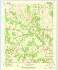
1964 Map of Overbrook
USGS Topo · Published 1975About this map
Criner Hills and the winding course of Hickory Creek dominate this mid-1960s landscape along the border of Carter and Love counties. The settlement of Overbrook sits as a primary transit point along the Gulf Colorado and Santa Fe railroad, which runs parallel to a major highway corridor under construction at the time of the survey. The map captures a rural economy defined by resource extraction and scattered homesteads, evidenced by numerous Gravel Pits and the Morgan Field oil area. For family historians, the sheet preserves the locations of several community focal points, including McAlester Ch, Pleasant Hill Ch, and the Criner Cem. Smaller hamlets like Marsden, Brock, and Greenville are clearly delineated, showing the distribution of residents across the varied terrain of the Arbuckle Mountains' southern foothills.
Find a feature on this map
20 named features on this map. Tap any name to fly to it.
Don’t see what you’re looking for? This feature index may not catch every label — zoom into the map to look around manually.
Map Details
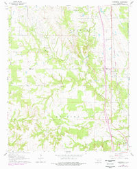
Editions of this 1964 Overbrook Map
3 editions found

Other maps of this area

1901 · Ardmore
USGS Topo · 1:125,000

1902 · Gainesville
USGS Topo · 1:125,000

1918 · Ardmore
USGS Topo · 1:125,000

1943 · Gainesville
USGS Topo · 1:125,000

1954 · Sherman
USGS Topo · 1:250,000

1957 · Ardmore
USGS Topo · 1:250,000

1958 · Sherman
USGS Topo · 1:250,000

1963 · Ardmore
USGS Topo · 1:250,000

1964 · Lake Murray
USGS Topo · 1:24,000

1964 · Ardmore East
USGS Topo · 1:24,000