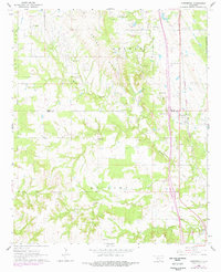
1964 Map of Overbrook
USGS Topo · Published 1978About this map
The Criner Hills rise above the agricultural and oil-producing landscape of southern Oklahoma along the border of Carter Co and Love Co. This survey, updated with revisions from the late 1970s, captures the rural character of the region as the Atchison Topeka and Santa Fe railroad runs parallel to the eastern boundary near the settlement of Overbrook. The land is defined by the drainage of Hickory Creek and its various tributaries, including Spring Branch and Little Hickory Creek. Local community life is anchored by several rural churches and cemeteries, such as Crinerville Ch and the McAlester Cem. The presence of many Oil Wells and Gravel Pits reflects the extractive economy of the era, while the Lake Murray State Park Bdy on the eastern edge marks the transition toward recreational land use.
Find a feature on this map
32 named features on this map. Tap any name to fly to it.
Don’t see what you’re looking for? This feature index may not catch every label — zoom into the map to look around manually.
Map Details
Editions of this 1964 Overbrook Map
3 editions found

Other maps of this area

1901 · Ardmore
USGS Topo · 1:125,000

1902 · Gainesville
USGS Topo · 1:125,000

1918 · Ardmore
USGS Topo · 1:125,000

1943 · Gainesville
USGS Topo · 1:125,000

1954 · Sherman
USGS Topo · 1:250,000

1957 · Ardmore
USGS Topo · 1:250,000

1958 · Sherman
USGS Topo · 1:250,000

1963 · Ardmore
USGS Topo · 1:250,000

1964 · Lake Murray
USGS Topo · 1:24,000

1964 · Ardmore East
USGS Topo · 1:24,000