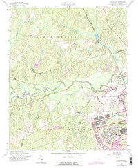
1957 Map of Overhills
USGS Topo · Published 1973About this map
Fort Bragg Military Reservation and the sprawling infrastructure of Pope Air Force Base dominate the southern half of this landscape, showing the massive mid-century footprint of these critical military installations. The Little River carves a winding path through the center of the sheet, separating the base from the northern townships. To the north, the settlement of Overhills sits along the Seaboard Coast Line railroad, adjacent to a golf course and Overhills Lake. This area reveals a transition from the intensive military development of the base, with its organized grids of barracks and athletic fields, to the more rural drainages of Buffalo Creek and Hector Creek. Notable landmarks for researchers include the Murray Sch and several large impoundments such as McKellars Pond and McFayden Pond.
Find a feature on this map
34 named features on this map. Tap any name to fly to it.
Don’t see what you’re looking for? This feature index may not catch every label — zoom into the map to look around manually.
Map Details
Editions of this 1957 Overhills Map
This is the sole edition of this map. No revisions or reprints were ever made.
Other maps of this area

1948 · Fayetteville
USGS Topo · 1:62,500

1948 · Clifdale
USGS Topo · 1:62,500

1948 · Nicholson Creek
USGS Topo · 1:24,000

1948 · Clifdale
USGS Topo · 1:24,000

1950 · Clifdale
USGS Topo · 1:24,000

1950 · Lobelia
USGS Topo · 1:24,000

1950 · Fayetteville
USGS Topo · 1:24,000

1950 · Manchester
USGS Topo · 1:24,000

1950 · Nicholson Creek
USGS Topo · 1:24,000

1951 · Clifdale
USGS Topo · 1:62,500