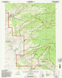
1992 Map of Overlook Hill
USGS Topo · Published 1996About this map
The Medicine Bow National Forest dominates this section of Wyoming, where the high-altitude hydrology of the Snowy Range is meticulously documented through irrigation and wilderness management. Several ranching outposts, including the A Bar A Ranch and French Creek Ranch, sit along the complex network of mountain streams that feed into the North Platte River. The mapping of the Hubbell Ditch, Finfrock Ditch, and Anderson Ditch illustrates the vital role of water rights and engineering in sustaining these remote holdings.
Find a feature on this map
37 named features on this map. Tap any name to fly to it.
Don’t see what you’re looking for? This feature index may not catch every label — zoom into the map to look around manually.
Map Details
Editions of this 1992 Overlook Hill Map
This is the sole edition of this map. No revisions or reprints were ever made.
Other maps of this area

1906 · Medicine Bow
USGS Topo · 1:125,000

1908 · Medicine Bow
USGS Topo · 1:125,000

1939 · Saratoga
USGS Topo · 1:125,000

1954 · Rawlins
USGS Topo · 1:250,000

1958 · Rawlins
USGS Topo · 1:250,000
1961 · Elkhorn Point
USGS Topo · 1:24,000

1961 · Overlook Hill
USGS Topo · 1:24,000

1961 · Ryan Park
USGS Topo · 1:24,000
1961 · Trent Creek
USGS Topo · 1:24,000
1961 · Horatio Rock
USGS Topo · 1:24,000