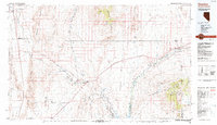
1987 Map of Overton
USGS Topo · Published 1988About this map
The Union Pacific railroad and Interstate 15 define the transit corridors of northeastern Clark County in the late 1980s, tracing a path through the Moapa River Indian Reservation and the desert floor. This terrain is characterized by the convergence of several major washes, such as Kane Springs Wash and Meadow Valley Wash, which feed into the Muddy River. In the southern reaches, the map details the agricultural and ranching communities of Logandale and Overton situated just north of Lake Mead. The dramatic topography includes the Mormon Mesa and the Valley of Fire State Park, showing a landscape defined by sharp elevation changes and seasonal watercourses. Further east, the Virgin River valley supports the border settlements of Bunkerville and Mesquite at the Arizona state line.
Find a feature on this map
69 named features on this map. Tap any name to fly to it.
Don’t see what you’re looking for? This feature index may not catch every label — zoom into the map to look around manually.
Map Details
Editions of this 1987 Overton Map
2 editions found
Other maps of this area

1885 · St. George
USGS Topo · 1:250,000

1885 · Pioche
USGS Topo · 1:250,000

1886 · Saint Thomas
USGS Topo · 1:250,000

1886 · Mt. Trumbull
USGS Topo · 1:250,000

1886 · Pioche
USGS Topo · 1:250,000

1891 · St. George
USGS Topo · 1:250,000

1892 · Mt. Trumbull
USGS Topo · 1:250,000

1893 · Saint Thomas
USGS Topo · 1:250,000

1907 · Las Vegas
USGS Topo · 1:250,000

1908 · Las Vegas
USGS Topo · 1:250,000