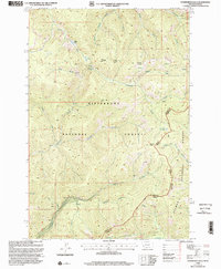
1998 Map of Overwhich Falls
USGS Topo · Published 2002About this map
Bitterroot National Forest straddles the high mountain divide between Montana and Idaho, characterized by a complex drainage network that feeds the North Fork Salmon River. This 1998 revision reveals a landscape defined by significant elevation changes, where named landmarks like Falls Point and Hughes Point overlook deep canyons and tributary headwaters. The map identifies several high-altitude water bodies, including Capri Lake and Pass Lake, which transition into steep drainages such as Drop Creek and Capri Creek.
Find a feature on this map
37 named features on this map. Tap any name to fly to it.
Don’t see what you’re looking for? This feature index may not catch every label — zoom into the map to look around manually.
Map Details
Editions of this 1998 Overwhich Falls Map
This is the sole edition of this map. No revisions or reprints were ever made.
Other maps of this area

1955 · Dillon
USGS Topo · 1:250,000

1956 · Elk City
USGS Topo · 1:250,000

1957 · Dillon
USGS Topo · 1:250,000

1958 · Dillon
USGS Topo · 1:250,000

1960 · Elk City
USGS Topo · 1:250,000

1960 · Piquett Mountain
USGS Topo · 1:62,500

1962 · Dillon
USGS Topo · 1:250,000

1964 · Piquett Creek
USGS Topo · 1:24,000

1965 · Dillon
USGS Topo · 1:250,000

1965 · Medicine Hot Springs
USGS Topo · 1:24,000