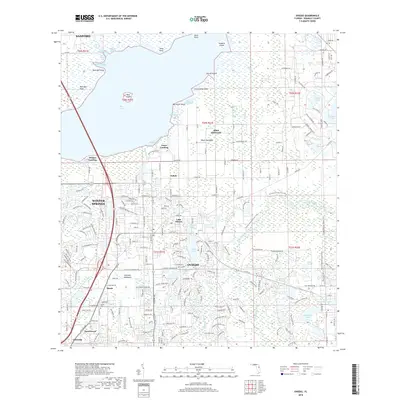
2018 Map of Oviedo
USGS Topo · Published 2018About this map
Oviedo and Winter Springs serve as the primary anchors for this Seminole County landscape, where modern suburban development meets the expansive southern reaches of Lake Jesup. The map highlights a transition from the marshy edges of Marl Bed Flats and Black Hammock to the dense street networks that characterize the contemporary growth of these communities. Water defines the topography, with the Little Econlockhatchee River and the Econlockhatchee River carving through the eastern and southern sectors. Smaller settlements such as Slavia, which includes the Slavia Cem, and Jamestown provide a record of local community identities. The presence of the Florida National Scenic Trail winding through the terrain indicates the preservation of corridors amid the residential expansion, connecting major points like Mitchell Hammock to the outlying lakes including Long Lake and Lake Charm.
Find a feature on this map
70 named features on this map. Tap any name to fly to it.
Don’t see what you’re looking for? This feature index may not catch every label — zoom into the map to look around manually.
Map Details
Editions of this 2018 Oviedo Map
This is the sole edition of this map. No revisions or reprints were ever made.
Other maps of this area

1949 · Osceola
USGS Topo · 1:24,000

1953 · Geneva
USGS Topo · 1:24,000

1953 · Oviedo SW
USGS Topo · 1:24,000

1953 · Bithlo
USGS Topo · 1:24,000

1955 · Orlando
USGS Topo · 1:250,000

1956 · Oviedo
USGS Topo · 1:24,000

1956 · Orlando East
USGS Topo · 1:24,000

1957 · Orlando
USGS Topo · 1:250,000

1958 · Orlando
USGS Topo · 1:250,000

1962 · Orlando
USGS Topo · 1:250,000