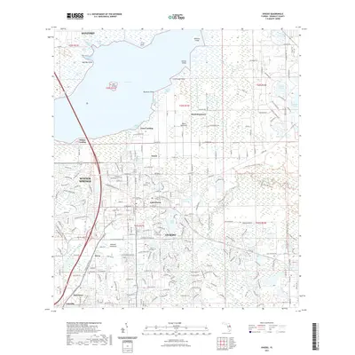
2021 Map of Oviedo
USGS Topo · Published 2021About this map
The Econlockhatchee River and its tributary, the Little Econlockhatchee River, carve through the eastern reaches of Seminole County, defining the drainage of a landscape transitioning from the marshes of Lake Jesup to suburban growth. This 2021 survey documents the dense corridor of Oviedo and Winter Springs, where modern developments are interleaved with historical markers of early Florida settlement. Local genealogy and history are preserved in the Oviedo Cem, Slavia Cem, and Hill Cem, which sit near long-established communities like Slavia and Jamestown. To the north, the terrain gives way to the wetlands of Black Hammock and several named points such as Big Gator Point and Marl Bed Point along the lake shore. The map also traces modern recreation through the Cross Seminole Trl and Florida National Scenic Trl, showing how current infrastructure follows the path of the region's diverse ecological and human history.
Find a feature on this map
83 named features on this map. Tap any name to fly to it.
Don’t see what you’re looking for? This feature index may not catch every label — zoom into the map to look around manually.
Map Details
Editions of this 2021 Oviedo Map
This is the sole edition of this map. No revisions or reprints were ever made.
Other maps of this area

1949 · Osceola
USGS Topo · 1:24,000

1953 · Geneva
USGS Topo · 1:24,000

1953 · Oviedo SW
USGS Topo · 1:24,000

1953 · Bithlo
USGS Topo · 1:24,000

1955 · Orlando
USGS Topo · 1:250,000

1956 · Oviedo
USGS Topo · 1:24,000

1956 · Orlando East
USGS Topo · 1:24,000

1957 · Orlando
USGS Topo · 1:250,000

1958 · Orlando
USGS Topo · 1:250,000

1962 · Orlando
USGS Topo · 1:250,000