
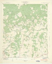
1936 Map of Ovoca
USGS Topo · Published 1936About this map
The Ovoca Orphans Home and the adjacent Ovoca Lake serve as a central landmark in this 1936 Tennessee Valley Authority survey of the Coffee County area. The landscape is defined by the winding course of the Duck River, which is traversable at numerous named crossing points including Beckman Ford, Richardson Ford, and Waite Ford. These fords, alongside a dense network of country schools such as Fourth Model Sch and Flower Town Sch, reveal a rural society still deeply reliant on local water crossings and neighborhood-level institutions before the widespread modernization of the mid-20th century.
Find a feature on this map
76 named features on this map. Tap any name to fly to it.
Don’t see what you’re looking for? This feature index may not catch every label — zoom into the map to look around manually.
Map Details
Editions of this 1936 Ovoca Map
This is the sole edition of this map. No revisions or reprints were ever made.
Other maps of this area

1913 · Hollow Springs
USGS Topo · 1:62,500

1936 · Fredonia
USGS Topo · 1:24,000

1936 · Manchester
USGS Topo · 1:24,000

1936 · Cumberland Springs
USGS Topo · 1:24,000

1936 · Noah
USGS Topo · 1:24,000

1936 · Wartrace
USGS Topo · 1:24,000

1936 · Camp Peay
USGS Topo · 1:24,000

1936 · Capitol Hill
USGS Topo · 1:24,000

1936 · Normandy
USGS Topo · 1:24,000
1941 · Capitol Hill
USGS Topo · 1:24,000