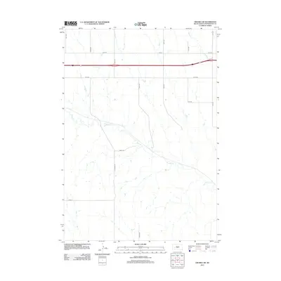
2012 Map of Owanka SW
USGS Topo · Published 2012About this map
Boxelder Cr meanders across this rural landscape in Pennington County, defining the drainage patterns of the western Great Plains during the early 21st century. The map reveals a strictly regulated section-line road network typical of South Dakota's homesteading heritage, where modern thoroughfares like Hwy-1416 intersect with locally significant routes such as Koch Rd and Marty Rd. North of the creek, Patterson Cr flows through open terrain, illustrating the sparse but vital water sources in this semi-arid region. The presence of family-named roads like Sharpe Rd and Soward Rd suggests the enduring influence of local landholders on the geography of the Owanka area, providing a precise look at property access and land use before subsequent rural development.
Find a feature on this map
16 named features on this map. Tap any name to fly to it.
Don’t see what you’re looking for? This feature index may not catch every label — zoom into the map to look around manually.
Map Details
Editions of this 2012 Owanka SW Map
This is the sole edition of this map. No revisions or reprints were ever made.
Other maps of this area
1953 · Viewfield
USGS Topo · 1:24,000
1953 · New Underwood
USGS Topo · 1:24,000
1953 · Caputa NE
USGS Topo · 1:24,000

1953 · Rapid City
USGS Topo · 1:250,000
1954 · Owanka
USGS Topo · 1:24,000
1954 · Creston
USGS Topo · 1:24,000
1954 · Brennan Flat
USGS Topo · 1:24,000

1955 · Hot Springs
USGS Topo · 1:250,000

1957 · Rapid City
USGS Topo · 1:250,000
1957 · Owanka NE
USGS Topo · 1:24,000