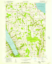
1955 Map of Owasco
USGS Topo · Published 1957About this map
The eastern shore of Owasco Lake and the western edge of Skaneateles Lake define this mid-century landscape in Cayuga County. The terrain is characterized by long, sloping ridges dotted with small agricultural crossroads like Niles, Austin, and Twelve Corners. Evidence of early rural infrastructure remains visible through numbered schoolhouses such as School No. 7 and several local burial grounds, including the Owasco Rural Cemetery and the West Niles Rural Cemetery.
Find a feature on this map
77 named features on this map. Tap any name to fly to it.
Don’t see what you’re looking for? This feature index may not catch every label — zoom into the map to look around manually.
Map Details
Editions of this 1955 Owasco Map
3 editions found
Other maps of this area

1898 · Moravia
USGS Topo · 1:62,500

1899 · Auburn
USGS Topo · 1:62,500

1899 · Skaneateles
USGS Topo · 1:62,500

1902 · Skaneateles
USGS Topo · 1:62,500

1902 · Moravia
USGS Topo · 1:62,500

1902 · Genoa
USGS Topo · 1:62,500

1902 · Auburn
USGS Topo · 1:62,500

1942 · Genoa
USGS Topo · 1:24,000

1943 · Moravia
USGS Topo · 1:31,680
1943 · Genoa
USGS Topo · 1:31,680