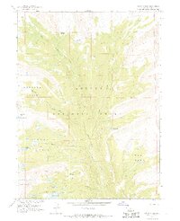
1967 Map of Oweep Creek
USGS Topo · Published 1968About this map
Ashley National Forest dominates this 1967 survey, revealing a high-altitude landscape defined by glacially carved bowls and an extensive network of alpine water. The drainage is anchored by the Lake Fork River and Oweep Creek, which gather runoff from numerous high-country lakes including Cleveland Lake and Stewart Lake. This map represents the area before modern wilderness management, focusing on the intricate topography of the Brown Duck Mountain region. High passes such as Cleveland Pass and East Basin Pass connect distinct geographic zones like Ottoson Basin and West Park, while established pack trails provide the primary means of navigation through the steep elevation changes. The presence of named clearings like Lambert Meadow suggests a history of grazing or seasonal use in these remote high-elevation basins.
Find a feature on this map
24 named features on this map. Tap any name to fly to it.
Don’t see what you’re looking for? This feature index may not catch every label — zoom into the map to look around manually.
Map Details
Editions of this 1967 Oweep Creek Map
2 editions found
Other maps of this area

1885 · Uinta
USGS Topo · 1:250,000

1901 · Hayden Peak
USGS Topo · 1:125,000

1903 · Hayden Peak
USGS Topo · 1:125,000

1905 · Gilbert Peak
USGS Topo · 1:125,000

1906 · Gilbert Peak
USGS Topo · 1:125,000

1954 · Salt Lake City
USGS Topo · 1:250,000

1958 · Salt Lake City
USGS Topo · 1:250,000

1960 · Salt Lake City
USGS Topo · 1:250,000
1967 · Kidney Lake
USGS Topo · 1:24,000

1967 · Explorer Peak
USGS Topo · 1:24,000