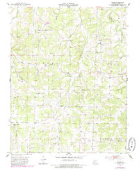
1951 Map of Owens
USGS Topo · Published 1985About this map
The Gasconade River winds through the northwest corner of this Wright County landscape, anchoring a rural network of ridges and hollows defined by small-scale farming and community life. In the early 1950s, the area around Owens remained a landscape of country schools and churches, including Rock Chapel, Oak Grove Ch, and Liberty Sch. This survey reveals a deeply local geography where family-named landmarks like Frog Knob and Bruton Sinks neighbor numerous family cemeteries such as Kennel Cem and Ussery Cem. The distribution of these features, along with the Crossroads Store, illustrates the decentralized settlement pattern characteristic of the Ozark plateau before mid-century consolidation. Drainage ways like Evening Shade Branch and Whetstone Creek carve out the topography, guiding the placement of older homesteads and the winding rural routes that connected these isolated homesteads.
Find a feature on this map
45 named features on this map. Tap any name to fly to it.
Don’t see what you’re looking for? This feature index may not catch every label — zoom into the map to look around manually.
Map Details
Editions of this 1951 Owens Map
2 editions found
Other maps of this area

1931 · Manes
USGS Topo · 1:48,000

1941 · Manes
USGS Topo · 1:62,500

1943 · Manes
USGS Topo · 1:62,500

1951 · Norwood
USGS Topo · 1:24,000

1951 · Mountain Grove South
USGS Topo · 1:24,000

1951 · Mountain Grove North
USGS Topo · 1:24,000

1951 · Owens
USGS Topo · 1:24,000

1951 · Mansfield NE
USGS Topo · 1:24,000
1951 · Mansfield
USGS Topo · 1:24,000

1951 · Mountain Grove
USGS Topo · 1:62,500