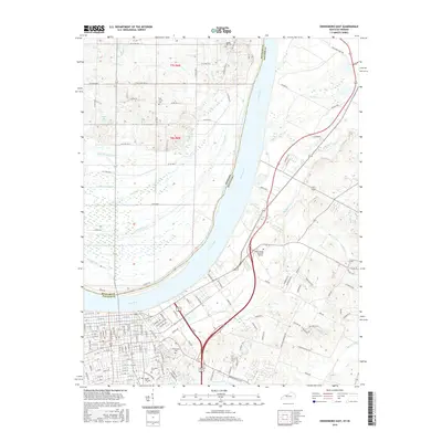
2016 Map of Owensboro East
USGS Topo · Published 2016About this map
Owensboro sits prominently at a wide bend of the Ohio River in this detailed survey, showing a landscape defined by industrial expansion and the historical placement of numerous civic landmarks. The city's eastern edge is notably punctuated by a concentration of significant burial grounds, including Greenwood Cem, Elmwood Cem, and Rose Hill Cem, which offer rich territory for genealogical research. Across the river to the north, the terrain shifts into the rural sections of Spencer County, Indiana, where tributaries like Kelly Cr and Pup Cr drain toward the river. The complex drainage network on the Kentucky side is represented by features like Caney Cr and Garrett Cr, which weave through the developing suburban grid. This edition documents the modern road network, including Rockport Ferry Rd and Keenland Pkwy, illustrating how the region has integrated its riverfront heritage with contemporary infrastructure.
Find a feature on this map
139 named features on this map. Tap any name to fly to it.
Don’t see what you’re looking for? This feature index may not catch every label — zoom into the map to look around manually.
Map Details
Editions of this 2016 Owensboro East Map
This is the sole edition of this map. No revisions or reprints were ever made.
Other maps of this area

1901 · Owensboro
USGS Topo · 1:62,500

1903 · Tell City
USGS Topo · 1:62,500

1906 · Sutherland
USGS Topo · 1:62,500

1907 · Whitesville
USGS Topo · 1:62,500

1909 · Whitesville
USGS Topo · 1:62,500

1952 · Owensboro East
USGS Topo · 1:24,000

1952 · Rockport
USGS Topo · 1:24,000

1952 · Owensboro West
USGS Topo · 1:24,000

1953 · Philpot
USGS Topo · 1:24,000

1953 · Sutherland
USGS Topo · 1:24,000