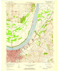
1956 Map of Owensboro East
USGS Topo · Published 1957About this map
The Ohio River dominates this mid-century landscape, separating the growing city of Owensboro, Kentucky, from the rural bottomlands of Spencer County, Indiana. The map captures a high degree of institutional detail within the city, specifically identifying educational landmarks such as Brescia College, Western High Sch, and Technical High Sch. The riverfront is active with infrastructure including a Coast Guard Depot and a protective Levee system near Bank Island.
Find a feature on this map
45 named features on this map. Tap any name to fly to it.
Don’t see what you’re looking for? This feature index may not catch every label — zoom into the map to look around manually.
Map Details
Editions of this 1956 Owensboro East Map
This is the sole edition of this map. No revisions or reprints were ever made.
Other maps of this area

1901 · Owensboro
USGS Topo · 1:62,500

1903 · Tell City
USGS Topo · 1:62,500

1906 · Sutherland
USGS Topo · 1:62,500

1907 · Whitesville
USGS Topo · 1:62,500

1909 · Whitesville
USGS Topo · 1:62,500

1952 · Owensboro East
USGS Topo · 1:24,000

1952 · Rockport
USGS Topo · 1:24,000

1952 · Owensboro West
USGS Topo · 1:24,000

1953 · Philpot
USGS Topo · 1:24,000

1953 · Sutherland
USGS Topo · 1:24,000