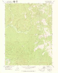
1979 Map of Owl Creek
USGS Topo · Published 1979About this map
The Van Duzen River flows through the southwestern corner of this Humboldt County landscape, passing the small settlement of Hely and markers for Mile 11 and Mile 12. To the north, the terrain is defined by a dense network of drainage systems, including Yager Creek, Owl Creek, and several forks that carve through high ridges and openings like Mc Cord Prairie and Bootjack Prairie. This 1970s survey captures a wilderness interface where timber and ranching history are evident in features like Shaws Ranch and the winding Redwood House Road. The map provides a precise record of late-20th-century access, showing a variety of primitive routes such as the Stevens Trail and numerous jeep and pack trails that traverse the steep topography between Black Butte and Bald Jesse.
Find a feature on this map
40 named features on this map. Tap any name to fly to it.
Don’t see what you’re looking for? This feature index may not catch every label — zoom into the map to look around manually.
Map Details
Editions of this 1979 Owl Creek Map
2 editions found
Other maps of this area

1919 · Glynn
USGS Topo · 1:62,500

1921 · Dyerville
USGS Topo · 1:62,500

1922 · Kneeland
USGS Topo · 1:62,500

1944 · Fortuna
USGS Topo · 1:62,500

1949 · Eureka
USGS Topo · 1:250,000

1949 · Weott
USGS Topo · 1:62,500

1950 · Iaqua Buttes
USGS Topo · 1:62,500

1950 · Scotia
USGS Topo · 1:62,500

1951 · Scotia
USGS Topo · 1:62,500

1951 · Weott
USGS Topo · 1:62,500