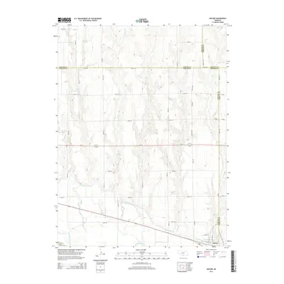
2014 Map of Oxford
USGS Topo · Published 2014About this map
The town of Oxford anchors the southeastern corner of this map, situated where the Republican River and the Cambridge Canal parallel one another. This 2014 survey reveals an agricultural landscape defined by water management and section-line roads across the borderlands of Furnas, Gosper, Phelps, and Harlan counties. To the north, the terrain is shaped by several drainages, including Swartz Cr and Turkey Cr, which are punctuated by man-made impoundments like Maaske Reservoir and Grove Reservoir. Local history and genealogy interests are represented by the Kellner Cem located on the eastern edge of the quadrangle. The infrastructure reflects a high-plains economy, with irrigation systems like the canal supporting the river valley and a dense grid of rural routes such as Bertrand Rd and Co Line Rd connecting dispersed farmsteads to the primary corridors of Us-34 and Highway 136.
Find a feature on this map
36 named features on this map. Tap any name to fly to it.
Don’t see what you’re looking for? This feature index may not catch every label — zoom into the map to look around manually.
Map Details
Editions of this 2014 Oxford Map
This is the sole edition of this map. No revisions or reprints were ever made.
Other maps of this area

1896 · Arapahoe
USGS Topo · 1:125,000

1898 · Arapahoe
USGS Topo · 1:125,000

1955 · Grand Island
USGS Topo · 1:250,000

1957 · Grand Island
USGS Topo · 1:250,000

1958 · Grand Island
USGS Topo · 1:250,000

1958 · Edison
USGS Topo · 1:24,000

1958 · Hollinger
USGS Topo · 1:24,000
1958 · Beaver City
USGS Topo · 1:24,000

1958 · Stamford
USGS Topo · 1:24,000

1958 · Mascot
USGS Topo · 1:24,000