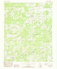
1984 Map of Oxford
USGS Topo · Published 1984About this map
Oxford sits as the central hub of this North Arkansas landscape, where the Strawberry River and its numerous tributaries like Sandy Creek and Powell Creek carve through the Izard County terrain. In the early 1980s, the area's social geography was defined by small crossroads settlements and numerous family and community burial grounds, such as Campground Cem and Blankenship Cem. Further south, the map documents Brockwell and the settlement of Band Mill, the latter situated near the confluence of Band Mill Creek and East Fork Creek. The presence of several Gravel Pits and a prominent Wooden Pole Trans Line cutting across the northern reaches illustrates the rural infrastructure supporting these small communities. This survey is particularly valuable for genealogical research, pinpointing isolated landmarks like Thorn Hill and Wyatt Cem tucked into the Dry Hollow valley.
Find a feature on this map
28 named features on this map. Tap any name to fly to it.
Don’t see what you’re looking for? This feature index may not catch every label — zoom into the map to look around manually.
Map Details
Editions of this 1984 Oxford Map
This is the sole edition of this map. No revisions or reprints were ever made.
Other maps of this area

1890 · Mountain Home
USGS Topo · 1:125,000

1891 · Mountain Home
USGS Topo · 1:125,000

1894 · Mountain Home
USGS Topo · 1:125,000

1945 · Harrison
USGS Topo · 1:250,000

1949 · Harrison
USGS Topo · 1:250,000

1950 · Salem
USGS Topo · 1:62,500

1951 · Salem
USGS Topo · 1:62,500

1951 · Melbourne
USGS Topo · 1:62,500

1954 · Harrison
USGS Topo · 1:250,000

1957 · Poplar Bluff
USGS Topo · 1:250,000