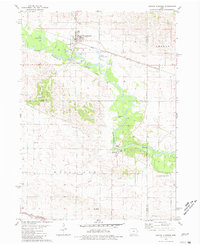
1980 Map of Oxford Junction
USGS Topo · Published 1981About this map
Oxford Junction serves as the focal point for this eastern Iowa landscape, situated where the Chicago Milwaukee St Paul and Pacific line meets the winding Wapsipinicon River. The map captures a transitional rural economy, featuring several active extraction sites like the Gravel Pit and Sandpit alongside the river's edge. To the south, the village of Massillon is perched near the Cedar County line, while Oxford Mills marks an older river-oriented settlement site.
Find a feature on this map
35 named features on this map. Tap any name to fly to it.
Don’t see what you’re looking for? This feature index may not catch every label — zoom into the map to look around manually.
Map Details
Editions of this 1980 Oxford Junction Map
This is the sole edition of this map. No revisions or reprints were ever made.
Other maps of this area

1889 · Tipton
USGS Topo · 1:62,500

1890 · Tipton
USGS Topo · 1:62,500

1891 · Monticello
USGS Topo · 1:62,500

1891 · Baldwin
USGS Topo · 1:62,500

1892 · Wheatland
USGS Topo · 1:62,500

1894 · Wheatland
USGS Topo · 1:62,500

1900 · Anamosa
USGS Topo · 1:125,000

1901 · Peosta
USGS Topo · 1:125,000

1901 · Rock Island
USGS Topo · 1:125,000

1901 · Stanwood
USGS Topo · 1:125,000