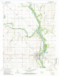
1965 Map of Oxford
USGS Topo · Published 1983About this map
The confluence of the Ninnescah River and the Arkansas River anchor this mid-century portrait of southern Kansas. The town of Oxford serves as the primary population center, situated near the Oxford Cemetery and a network of water features including the Mill Race and a Powerhouse. The landscape is defined by the heavy footprint of transportation and energy extraction, visible through the Midland Valley Pacific and Atchison Topeka and Santa Fe rail lines that cross the territory. To the south, the Slick-Carson Oil Field and scattered Oil Wells indicate the region's industrial ties, while smaller locales like Whitman and Bushnell dot the rural townships. Genealogists may find the Ninnescah Cem particularly notable, located north of the river in a bend of the Ninnescah township.
Find a feature on this map
30 named features on this map. Tap any name to fly to it.
Don’t see what you’re looking for? This feature index may not catch every label — zoom into the map to look around manually.
Map Details
Editions of this 1965 Oxford Map
2 editions found
Other maps of this area

1890 · Wellington
USGS Topo · 1:125,000

1955 · Udall
USGS Topo · 1:24,000

1955 · Belle Plaine
USGS Topo · 1:24,000

1955 · Mulvane
USGS Topo · 1:24,000

1955 · Wichita
USGS Topo · 1:250,000

1958 · Wichita
USGS Topo · 1:250,000

1964 · South Haven NE
USGS Topo · 1:24,000

1964 · Dalton
USGS Topo · 1:24,000

1965 · Adamsville
USGS Topo · 1:24,000
1965 · Hackney
USGS Topo · 1:24,000