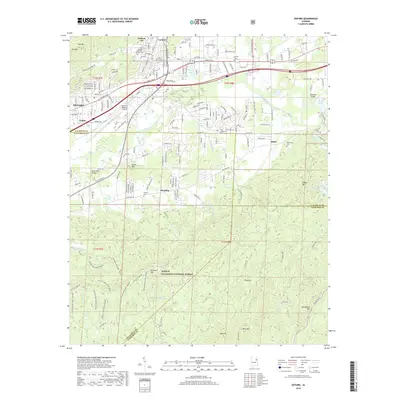
2018 Map of Oxford
USGS Topo · Published 2018About this map
Oxford and its neighboring communities sit at a geographic crossroads where the urban development of Hobson City and Lardent meets the protected ridges of the Talladega National Forest. This 2018 survey illustrates the complex boundary between modern infrastructure, like the Anniston Regional Airport, and the older rural footprint of settlements like McAding and Hicks. The topography is dominated by a series of prominent peaks, including Horseblock Mtn, Kentucky Mtn, and Oak Mtn, which define the drainage basins of Choccolocco Creek and Salt Creek. Several local burial grounds, such as Oxford Memorial Gardens Cem and the remote Antioch Cem, provide valuable reference points for genealogists. The southern half of the map is largely dedicated to the national forest, featuring a network of recreation trails including the Pinhoti NRT and various ORV loops such as Kentucky ORV Loop 1 White.
Find a feature on this map
64 named features on this map. Tap any name to fly to it.
Don’t see what you’re looking for? This feature index may not catch every label — zoom into the map to look around manually.
Map Details
Editions of this 2018 Oxford Map
This is the sole edition of this map. No revisions or reprints were ever made.
Other maps of this area

1891 · Ashland
USGS Topo · 1:125,000

1900 · Anniston
USGS Topo · 1:125,000

1947 · Oxford
USGS Topo · 1:24,000

1947 · Anniston
USGS Topo · 1:24,000

1947 · Eulaton
USGS Topo · 1:24,000

1947 · Munford
USGS Topo · 1:24,000

1950 · Anniston
USGS Topo · 1:62,500

1953 · Atlanta
USGS Topo · 1:250,000

1954 · Choccolocco
USGS Topo · 1:24,000

1956 · Munford
USGS Topo · 1:24,000