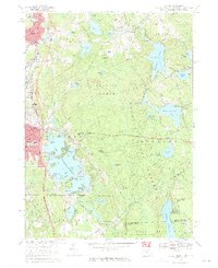
1969 Map of Oxford
USGS Topo · Published 1971About this map
The expansive waters of Lake Chaubunagungamaug dominate the central landscape of this three-state border region, where Massachusetts, Connecticut, and Rhode Island converge. This late-1960s survey documents a complex network of glacial ponds and reservoirs, including Manchaug Pond and the Whitin Reservoir, which supported the industrial development of villages like Manchaug and East Village. The map reveals a densely wooded southern interior through Douglas Woods and the Douglas State Forest, contrasted with the growing residential and commercial corridors in Oxford and Webster.
Find a feature on this map
124 named features on this map. Tap any name to fly to it.
Don’t see what you’re looking for? This feature index may not catch every label — zoom into the map to look around manually.
Map Details
Editions of this 1969 Oxford Map
4 editions found
Other maps of this area

1886 · Blackstone
USGS Topo · 1:62,500

1889 · Blackstone
USGS Topo · 1:62,500

1889 · Webster
USGS Topo · 1:62,500

1889 · Putnam
USGS Topo · 1:62,500

1889 · Burrillville
USGS Topo · 1:62,500

1892 · Webster
USGS Topo · 1:62,500

1893 · Putnam
USGS Topo · 1:62,500

1893 · Blackstone
USGS Topo · 1:62,500

1894 · Burrillville
USGS Topo · 1:62,500

1900 · Blackstone
USGS Topo · 1:62,500