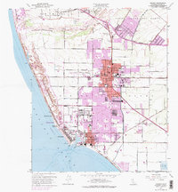
1949 Map of Oxnard
USGS Topo · Published 1974About this map
The coastal plains of the Santa Clara Valley are defined by a mix of agricultural heritage and rapid mid-century expansion. This map illustrates the convergence of transportation and industry, with the Southern Pacific and Ventura County Railway serving the bustling center of Oxnard. Near the coast, the Naval Reservation and the deep-water facilities at Port Hueneme mark the era's significant military and maritime presence. Historical land divisions are still visible through the boundaries of San Miguel (Olivas and Lorenzana) and Santa Clara Del Norte, preserving the layout of earlier ranchos.
Find a feature on this map
68 named features on this map. Tap any name to fly to it.
Don’t see what you’re looking for? This feature index may not catch every label — zoom into the map to look around manually.
Map Details
Editions of this 1949 Oxnard Map
4 editions found
Other maps of this area

1903 · Santa Paula
USGS Topo · 1:62,500

1904 · Ventura
USGS Topo · 1:62,500

1904 · Hueneme
USGS Topo · 1:62,500

1941 · Ventura
USGS Topo · 1:62,500

1942 · Santa Paula
USGS Topo · 1:62,500

1942 · Hueneme
USGS Topo · 1:62,500

1943 · Hueneme
USGS Topo · 1:62,500

1947 · Santa Paula
USGS Topo · 1:62,500

1949 · Los Angeles
USGS Topo · 1:250,000

1949 · Oxnard
USGS Topo · 1:24,000