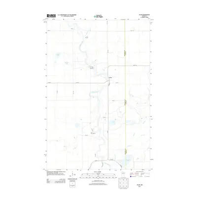
2013 Map of Oylen
USGS Topo · Published 2013About this map
The Crow Wing River winds through this central Minnesota landscape, defining the character of the small settlement of Oylen at the junction of Co Hwy-7 and Co Hwy-9. This 2013 survey captures a region defined by its water and recreational sites, where the river's path is mirrored by numerous smaller tributaries like Beaver Cr and Farnham Cr. For those tracing local family roots, Lyons Cem is located in the northern reaches near the river's bend, serving as a primary genealogical landmark for the area. The landscape is also characterized by several notable water bodies, including Sand Lake, Granning Lake, and Farnham Lake. Recreational development is evident through the presence of Little Round Hill Campground and Knob Hill Campground, both situated near the riverbanks, suggesting a long-standing local reliance on the waterway for both geography and leisure.
Find a feature on this map
32 named features on this map. Tap any name to fly to it.
Don’t see what you’re looking for? This feature index may not catch every label — zoom into the map to look around manually.
Map Details
Editions of this 2013 Oylen Map
This is the sole edition of this map. No revisions or reprints were ever made.
Other maps of this area

1919 · Leader
USGS Topo · 1:62,500

1953 · Brainerd
USGS Topo · 1:250,000

1957 · Brainerd
USGS Topo · 1:250,000

1958 · Brainerd
USGS Topo · 1:250,000

1965 · Brainerd
USGS Topo · 1:250,000

1966 · Staples NE
USGS Topo · 1:24,000
1966 · Motley NW
USGS Topo · 1:24,000

1966 · Aldrich North
USGS Topo · 1:24,000
1969 · Nimrod SW
USGS Topo · 1:24,000
1969 · Nimrod
USGS Topo · 1:24,000