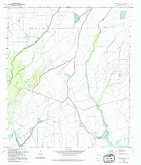
1994 Map of Oyster Bayou
USGS Topo · Published 1994About this map
The Anahuac Oil Field and Oyster Bayou Oil Field define the industrial character of this low-lying coastal landscape in Chambers County. Extensive networks of pipelines and access routes like Road on Levee weave between the salt marshes and bayous, illustrating the intensive petroleum extraction infrastructure of the late 20th century. This area is defined by the complex hydrology of the Double Bayou system and Oyster Bayou, where the flat terrain required significant water management efforts to support both industry and transit.
Find a feature on this map
14 named features on this map. Tap any name to fly to it.
Don’t see what you’re looking for? This feature index may not catch every label — zoom into the map to look around manually.
Map Details
Editions of this 1994 Oyster Bayou Map
This is the sole edition of this map. No revisions or reprints were ever made.
Other maps of this area

1931 · High Island
USGS Topo · 1:24,000

1931 · Frozen Point
USGS Topo · 1:24,000

1933 · Frozen Point
USGS Topo · 1:31,680

1933 · Whites Lake
USGS Topo · 1:31,680

1942 · Anahuac
USGS Topo · 1:24,000

1943 · High Island
USGS Topo · 1:31,680

1943 · Frozen Point
USGS Topo · 1:24,000
1943 · Lake Stephenson
USGS Topo · 1:24,000

1943 · Sea Breeze
USGS Topo · 1:24,000

1943 · Stowell
USGS Topo · 1:24,000