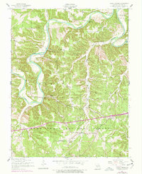
1954 Map of Ozark Springs
USGS Topo · Published 1977About this map
The Gasconade River dominates this mid-century landscape as it winds through the townships of Tavern, Gasconade, Liberty, and Cullen. The terrain is defined by deep incisions like Collie Hollow, York Hollow, and Laquey Hollow, creating a complex topography of ridges and bottoms within the Mark Twain National Forest. Local life is anchored by dispersed rural landmarks, including the Laquey School and numerous country churches such as Idumea Church and Center Point Church.
Find a feature on this map
28 named features on this map. Tap any name to fly to it.
Don’t see what you’re looking for? This feature index may not catch every label — zoom into the map to look around manually.
Map Details
Editions of this 1954 Ozark Springs Map
3 editions found
Other maps of this area

1936 · Waynesville
USGS Topo · 1:48,000

1941 · Big Piney
USGS Topo · 1:62,500

1942 · Waynesville
USGS Topo · 1:62,500

1943 · Richland
USGS Topo · 1:62,500

1943 · Big Piney
USGS Topo · 1:62,500

1943 · Drynob
USGS Topo · 1:62,500

1944 · Waynesville
USGS Topo · 1:62,500

1954 · Springfield
USGS Topo · 1:250,000
1954 · Hancock
USGS Topo · 1:24,000

1954 · Drynob
USGS Topo · 1:62,500