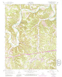
1954 Map of Ozark Springs
USGS Topo · Published 1985About this map
The Gasconade River winds through the heart of Pulaski County in this mid-century survey, creating a dramatic landscape of bluffs and hollows defined by the local water table. In the northwest, the river loops around Red Bluff and The Narrows, while smaller settlements like Ozark Springs and Buckhorn anchor the upland ridges. Local geography is deeply tied to family names and rural institutions, evidenced by a network of country churches including Center Point Church and Shady Grove Ch, and numerous family burial grounds like Dodds Cem and Bartlett Cem.
Find a feature on this map
29 named features on this map. Tap any name to fly to it.
Don’t see what you’re looking for? This feature index may not catch every label — zoom into the map to look around manually.
Map Details
Editions of this 1954 Ozark Springs Map
3 editions found
Other maps of this area

1936 · Waynesville
USGS Topo · 1:48,000

1941 · Big Piney
USGS Topo · 1:62,500

1942 · Waynesville
USGS Topo · 1:62,500

1943 · Richland
USGS Topo · 1:62,500

1943 · Big Piney
USGS Topo · 1:62,500

1943 · Drynob
USGS Topo · 1:62,500

1944 · Waynesville
USGS Topo · 1:62,500

1954 · Springfield
USGS Topo · 1:250,000
1954 · Hancock
USGS Topo · 1:24,000

1954 · Drynob
USGS Topo · 1:62,500