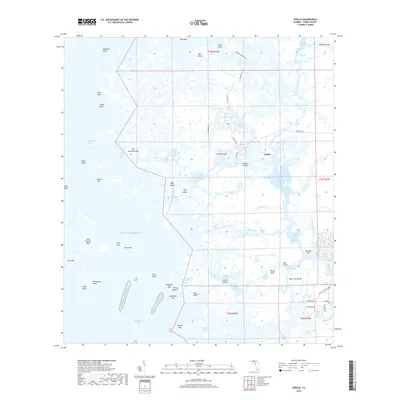
2018 Map of Ozello
USGS Topo · Published 2018About this map
Ozello serves as the central settlement in this intricate coastal landscape where the land fragments into a complex archipelago of islands and tidal creeks. Situated along the Gulf of Mexico, the area is defined by a labyrinthine network of waterways including the Saint Martins River and the Little Homosassa River. The transportation pattern follows the winding course of N Ozello Trl and W Ozello Trl, which provide the primary access to the scattered keys and points. To the south, the Chassahowitzka Swamp borders the marshy interface between the freshwater systems and the saltier reaches of Dixie Bay and Tiger Tail Bay. Notable landmarks like Paradise Island and the evocative Hell Gate illustrate the challenging navigation of this estuarine environment, while the presence of locations like Lashley Point suggests the enduring footprint of coastal habitation and fishing heritage in Citrus County.
Find a feature on this map
80 named features on this map. Tap any name to fly to it.
Don’t see what you’re looking for? This feature index may not catch every label — zoom into the map to look around manually.
Map Details
Editions of this 2018 Ozello Map
This is the sole edition of this map. No revisions or reprints were ever made.
Other maps of this area
1954 · Homosassa
USGS Topo · 1:24,000
1954 · Chassahowitzka Bay
USGS Topo · 1:24,000
1954 · Crystal River
USGS Topo · 1:24,000
1954 · Chassahowitzka
USGS Topo · 1:24,000
1954 · Red Level
USGS Topo · 1:24,000
1954 · Ozello
USGS Topo · 1:24,000
1955 · Plant City
USGS Topo · 1:250,000
1958 · Plant City
USGS Topo · 1:250,000
1959 · Plant City
USGS Topo · 1:250,000
1964 · Plant City
USGS Topo · 1:250,000