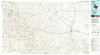
1985 Map of Ozona
USGS Topo · Published 1994About this map
The Pecos River carves a winding path through this West Texas landscape, marking the transition between the Edwards Plateau and the Trans-Pecos region. In the western reaches, the Fort Lancaster (Ruins) stand near Live Oak Creek, preserving the history of a frontier military post that once guarded the San Antonio-El Paso Road. The town of Ozona serves as the central hub of this region, surrounded by smaller settlements like Gurley and Crockett Heights.
Find a feature on this map
57 named features on this map. Tap any name to fly to it.
Don’t see what you’re looking for? This feature index may not catch every label — zoom into the map to look around manually.
Map Details
Editions of this 1985 Ozona Map
2 editions found
Other maps of this area

1895 · Sherwood
USGS Topo · 1:125,000

1920 · Big Lake
USGS Topo · 1:62,500

1920 · Barnhart
USGS Topo · 1:62,500

1922 · Big Lake
USGS Topo · 1:62,500

1922 · Barnhart
USGS Topo · 1:62,500

1928 · Crane
USGS Topo · 1:125,000

1928 · Sanderson
USGS Topo · 1:125,000

1928 · Rankin
USGS Topo · 1:125,000

1929 · Sheffield
USGS Topo · 1:125,000

1929 · Independence Draw Quadrangle
USGS Topo · 1:125,000