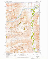
1954 Map of P N Ranch
USGS Topo · Published 1976About this map
The Missouri River and Judith River converge in this high-plains landscape, where the confluence is overlooked by the historic Old Fort Clagget (Site). The terrain is defined by massive natural features like Eightmile Bench and the broad depressions of The Big Sag and The Little Sag, illustrating the dramatic erosional history of the Missouri River Basin. Settlement patterns in the mid-1950s centered on major livestock operations, including the PN Ranch and the 79 Ranch Spring. Evidence of the frontier era remains visible through the Wagon Wheel Trail and a noted Grave (Historical) near Clagget Hill. Navigational hazards such as Deadman Rapids and notable landmarks like Hole-in-the-Wall underscore the Missouri's role as a primary artery for early transit and commerce through Chouteau and Fergus counties.
Find a feature on this map
30 named features on this map. Tap any name to fly to it.
Don’t see what you’re looking for? This feature index may not catch every label — zoom into the map to look around manually.
Map Details
Editions of this 1954 P N Ranch Map
2 editions found
Other maps of this area

1953 · Starve Out Flat
USGS Topo · 1:24,000

1954 · P N Ranch
USGS Topo · 1:24,000

1954 · Iliad
USGS Topo · 1:24,000

1954 · Council Island
USGS Topo · 1:24,000

1954 · Lewistown
USGS Topo · 1:250,000

1959 · Lewistown
USGS Topo · 1:250,000

1964 · Wolf Creek Falls
USGS Topo · 1:24,000

1964 · Pigtail Coulee
USGS Topo · 1:24,000

1964 · Anderson Bridge
USGS Topo · 1:24,000

1964 · Spring Coulee
USGS Topo · 1:24,000