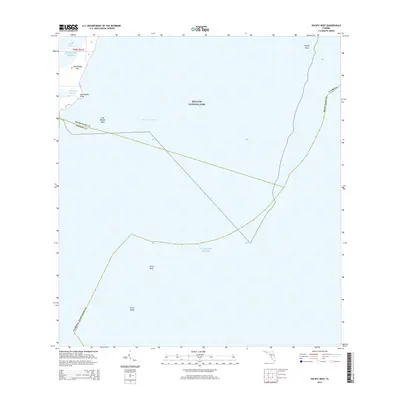
2015 Map of Pacific Reef
USGS Topo · Published 2015About this map
Biscayne National Park encompasses the vast majority of this maritime survey, illustrating the complex coral reef structures and shallow lagoons that define this portion of the Florida Keys. The map details the transition from the sheltered waters of Jones Lagoon and Old Rhodes Channel to the open Atlantic Ocean. Prominent navigational landmarks and underwater features include the expansive Pacific Reef along the eastern edge, as well as Turtle Reef and Turtle Rocks to the south. The northern tip of the keys is represented by Old Rhodes Key, featuring specific points of interest like Old Rhodes Point and Old Rhodes Bank. This 2015 edition provides a clear look at the boundaries between Miami-Dade and Monroe Counties as they extend through Hawk Channel and the surrounding reef systems.
Find a feature on this map
13 named features on this map. Tap any name to fly to it.
Don’t see what you’re looking for? This feature index may not catch every label — zoom into the map to look around manually.
Map Details
Editions of this 2015 Pacific Reef Map
This is the sole edition of this map. No revisions or reprints were ever made.
Other maps of this area

1947 · Garden Cove
USGS Topo · 1:24,000

1949 · Garden Cove
USGS Topo · 1:24,000

1949 · Elliott Key
USGS Topo · 1:24,000

1949 · Card Sound
USGS Topo · 1:24,000

1949 · Pacific Reef
USGS Topo · 1:24,000

1949 · Arsenicker Keys
USGS Topo · 1:24,000

1956 · Card Sound
USGS Topo · 1:24,000
1956 · Pacific Reef
USGS Topo · 1:24,000
1956 · Elliott Key
USGS Topo · 1:24,000
1956 · Arsenicker Keys
USGS Topo · 1:24,000