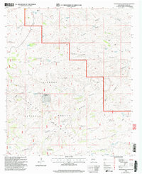
2001 Map of Packsaddle Canyon
USGS Topo · Published 2003About this map
Lincoln National Forest encompasses this arid landscape in the southern reaches of the Guadalupe Mountains, where the survival of cattle and livestock relied heavily on an extensive network of human-made water improvements. The map documents a rugged rangeland economy through labels for numerous basins and wells, including Antelope Well, Hog Lake, and Redwater Tank. Small pockets of early settlement or ranching operations appear at Anderson Ranch and Panama, though much of the terrain is defined by deep incisions like Packsaddle Canyon and Box Canyon. A complex infrastructure of water management is visible through specialized features such as the Wildhorse Mesa Water Storage Tank and Chimney Well Corral Water Storage Tank, illustrating the essential engineering required to sustain life and industry in this high-desert environment during the late 20th century.
Find a feature on this map
42 named features on this map. Tap any name to fly to it.
Don’t see what you’re looking for? This feature index may not catch every label — zoom into the map to look around manually.
Map Details
Editions of this 2001 Packsaddle Canyon Map
This is the sole edition of this map. No revisions or reprints were ever made.
Other maps of this area

1943 · Texas Hill
USGS Topo · 1:62,500

1945 · Texas Hill
USGS Topo · 1:62,500

1954 · Carlsbad
USGS Topo · 1:250,000

1958 · Carlsbad
USGS Topo · 1:250,000

1963 · Gowdy Ranch
USGS Topo · 1:24,000

1963 · Panama Ranch
USGS Topo · 1:24,000

1965 · Bullis Spring Ranch
USGS Topo · 1:24,000

1978 · Strychnine Draw
USGS Topo · 1:24,000

1978 · Artesia
USGS Topo · 1:100,000
1978 · South Taylor Tank
USGS Topo · 1:24,000