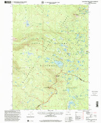
1997 Map of Packsaddle Mountain
USGS Topo · Published 2001About this map
Packsaddle Mountain and Little Roundtop Mountain dominate this high-country landscape on the border of Lane Co and Deschutes Co. The map documents a protected wilderness at the close of the twentieth century, where the Pacific Crest National Scenic Trail traverses the crest between the Willamette National Forest and Deschutes National Forest. This region, part of the Three Sisters Wilderness, is defined by its complex hydrology, with the headwaters of the South Fork McKenzie River fed by numerous springs and glacial lakes.
Find a feature on this map
75 named features on this map. Tap any name to fly to it.
Don’t see what you’re looking for? This feature index may not catch every label — zoom into the map to look around manually.
Map Details
Editions of this 1997 Packsaddle Mountain Map
This is the sole edition of this map. No revisions or reprints were ever made.
Other maps of this area

1925 · Waldo Lake
USGS Topo · 1:125,000

1929 · Three Sisters
USGS Topo · 1:125,000

1930 · Maiden Peak
USGS Topo · 1:125,000

1932 · Three Sisters
USGS Topo · 1:125,000

1934 · Maiden Peak
USGS Topo · 1:125,000

1934 · Mc Kenzie Bridge
USGS Topo · 1:96,000

1940 · Mc Kenzie Bridge
USGS Topo · 1:125,000

1953 · Salem
USGS Topo · 1:250,000

1954 · Salem
USGS Topo · 1:250,000

1955 · Chucksney Mtn
USGS Topo · 1:62,500