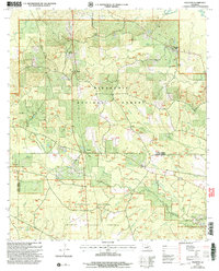
2003 Map of Packton
USGS Topo · Published 2005About this map
The Dugdemona River forms the northeastern boundary of this 2003 revision, a landscape defined by the dense pine and hardwood stands of the Kisatchie National Forest. This section of central Louisiana is characterized by its complex network of minor drainage systems, where small settlements like Packton and New Moore occupy the higher ground between creek branches. The southern portion of the map transitions into the Catahoula National Wildlife Management Preserve, emphasizing the region's managed timber and wildlife legacy. Local topography is most pronounced near Jordan Hill, where the land rises above the winding paths of Big Jordan Hill Creek and Cox Branch. The map provides a detailed view of the Winn Parish and Grant Parish line, showing the intricate parceling and forest service roads that serve these rural timber communities.
Find a feature on this map
27 named features on this map. Tap any name to fly to it.
Don’t see what you’re looking for? This feature index may not catch every label — zoom into the map to look around manually.
Map Details
Editions of this 2003 Packton Map
This is the sole edition of this map. No revisions or reprints were ever made.
Other maps of this area

1932 · Colfax NE
USGS Topo · 1:31,680

1932 · Colfax NW
USGS Topo · 1:31,680

1936 · Colfax
USGS Topo · 1:62,500

1936 · Pollock
USGS Topo · 1:62,500

1941 · Pollock
USGS Topo · 1:62,500

1950 · Winnfield
USGS Topo · 1:62,500

1951 · Winnfield
USGS Topo · 1:62,500

1953 · Alexandria
USGS Topo · 1:250,000

1954 · Tullos
USGS Topo · 1:62,500

1955 · Alexandria
USGS Topo · 1:250,000