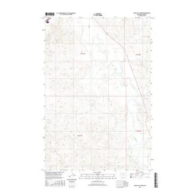
2017 Map of Paddy Fay Creek
USGS Topo · Published 2017About this map
The Tongue River meanders through this portion of Custer County, shaping a landscape defined by deep drainage systems and intermittent watercourses. This survey illustrates the intricate network of tributaries that feed into the main river valley, including Paddy Fay Creek and Cowles Cr. The terrain is characterized by the dissected uplands of southeastern Montana, where the presence of Lignite Cr points toward the region's underlying geology. Transportation in this sparsely populated area is limited to rural routes like Becker Ln, while the map's grid layout showcases the Public Land Survey System divisions across t7n r47e and surrounding townships. Other notable drainages include N Woman Cr and Mill Cr, which together illustrate the erosion patterns typical of the Montana plains.
Find a feature on this map
12 named features on this map. Tap any name to fly to it.
Don’t see what you’re looking for? This feature index may not catch every label — zoom into the map to look around manually.
Map Details
Editions of this 2017 Paddy Fay Creek Map
This is the sole edition of this map. No revisions or reprints were ever made.
Other maps of this area

1953 · Miles City
USGS Topo · 1:250,000

1957 · Miles City
USGS Topo · 1:250,000

1958 · Miles City
USGS Topo · 1:250,000

1968 · Big Hill
USGS Topo · 1:24,000

1968 · Miles City
USGS Topo · 1:24,000

1968 · Lignite Creek
USGS Topo · 1:24,000

1968 · Paddy Fay Creek
USGS Topo · 1:24,000
1969 · Jack Creek NW
USGS Topo · 1:24,000

1969 · Horse Creek
USGS Topo · 1:24,000

1969 · Circle L Creek
USGS Topo · 1:24,000