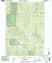
2004 Map of Paddy Flat
USGS Topo · Published 2007About this map
Paddy Flat and the surrounding high country of the Payette National Forest are defined by high-altitude peaks and a complex network of waterways. Significant peaks such as Buckhorn Mountain and Jughandle Mountain overlook several glacial lakes and basins, including Boulder Lake, Summit Lake, and Kennally Lakes. Evidence of high-country activity is visible through several labeled mines, an Adit, and a prospect site located near Twin Peaks.
Find a feature on this map
43 named features on this map. Tap any name to fly to it.
Don’t see what you’re looking for? This feature index may not catch every label — zoom into the map to look around manually.
Map Details
Editions of this 2004 Paddy Flat Map
This is the sole edition of this map. No revisions or reprints were ever made.
Other maps of this area

1911 · Meadows
USGS Topo · 1:125,000

1954 · Gold Fork
USGS Topo · 1:62,500

1954 · Cascade
USGS Topo · 1:62,500

1955 · Baker
USGS Topo · 1:250,000

1957 · Challis
USGS Topo · 1:250,000

1959 · Baker
USGS Topo · 1:250,000

1960 · Challis
USGS Topo · 1:250,000

1963 · Challis
USGS Topo · 1:250,000

1973 · Blackmare
USGS Topo · 1:24,000

1973 · Fitsum Peak
USGS Topo · 1:24,000