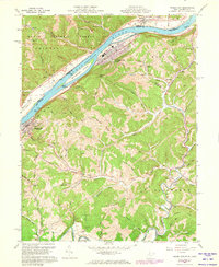
1960 Map of Paden City
USGS Topo · Published 1973About this map
The Ohio River dominates this mid-century landscape, acting as a busy industrial corridor between West Virginia and Ohio. Along the eastern bank, Paden City and Sistersville are established hubs connected by the Baltimore and Ohio railroad, which follows the river's curve past prominent features like Paden Island and Williamson Island. The mapping of fence and field lines via 1950s aerial photography provides a rare look at the division of rural upland parcels between the river and Middle Island Creek.
Find a feature on this map
76 named features on this map. Tap any name to fly to it.
Don’t see what you’re looking for? This feature index may not catch every label — zoom into the map to look around manually.
Map Details
Editions of this 1960 Paden City Map
4 editions found
Other maps of this area

1905 · West Union
USGS Topo · 1:62,500

1905 · New Matamoras
USGS Topo · 1:62,500

1906 · Saint Marys
USGS Topo · 1:62,500

1906 · New Martinsville
USGS Topo · 1:62,500

1924 · St Marys
USGS Topo · 1:62,500

1924 · New Martinsville
USGS Topo · 1:62,500

1924 · New Matamoras
USGS Topo · 1:62,500

1924 · West Union
USGS Topo · 1:62,500

1926 · New Martinsville
USGS Topo · 1:62,500

1926 · New Matamoras
USGS Topo · 1:62,500