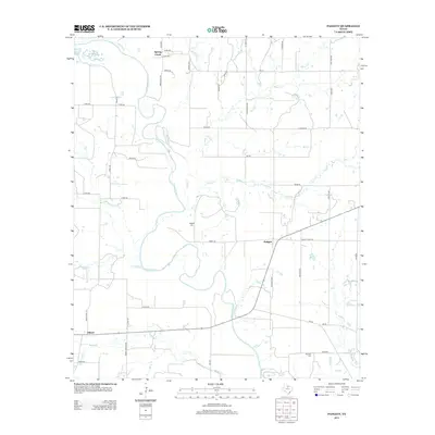
2013 Map of Padgett
USGS Topo · Published 2013About this map
The Brazos River meanders through this portion of Throckmorton County, creating a complex hydrologic landscape defined by numerous tributaries. Small rural settlements like Padgett and Elbert serve as anchors in a region where the road network, including Ranch Road 1711 and Ranch Road 2898, follows the topography of the creek valleys. The drainage patterns of Bitter Cr, Rabbit Cr, and Boggy Cr illustrate the watershed's influence on local land use and development in North Texas.
Find a feature on this map
51 named features on this map. Tap any name to fly to it.
Don’t see what you’re looking for? This feature index may not catch every label — zoom into the map to look around manually.
Map Details
Editions of this 2013 Padgett Map
This is the sole edition of this map. No revisions or reprints were ever made.
Other maps of this area

1954 · Wichita Falls
USGS Topo · 1:250,000

1958 · Wichita Falls
USGS Topo · 1:250,000

1963 · Megargel
USGS Topo · 1:24,000

1964 · Padgett
USGS Topo · 1:24,000
1964 · Lake Olney
USGS Topo · 1:24,000

1964 · Olney
USGS Topo · 1:24,000

1965 · Throckmorton NE
USGS Topo · 1:24,000

1966 · Westover SE
USGS Topo · 1:24,000
1966 · Proffitt
USGS Topo · 1:24,000
1966 · Westover
USGS Topo · 1:24,000