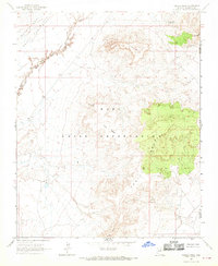
1967 Map of Padilla Mesa
USGS Topo · Published 1969About this map
Padilla Mesa and the surrounding high desert plateaus define this region of Northern Arizona during the late 1960s. The landscape is characterized by its significant cultural and administrative boundaries, notably the Hopi Indian Reservation and the Navajo Hopi Joint Use Area. These designations reflect a complex period of land management and ancestral heritage within Coconino and Navajo Counties.
Find a feature on this map
14 named features on this map. Tap any name to fly to it.
Don’t see what you’re looking for? This feature index may not catch every label — zoom into the map to look around manually.
Map Details
Editions of this 1967 Padilla Mesa Map
This is the sole edition of this map. No revisions or reprints were ever made.
Other maps of this area

1883 · Tusayan
USGS Topo · 1:250,000

1886 · Tusayan
USGS Topo · 1:250,000

1947 · Flagstaff
USGS Topo · 1:250,000

1954 · Flagstaff
USGS Topo · 1:250,000

1958 · Flagstaff
USGS Topo · 1:250,000

1960 · Flagstaff
USGS Topo · 1:250,000

1962 · Flagstaff
USGS Topo · 1:250,000

1966 · Oraibi
USGS Topo · 1:62,500

1966 · Tovar Mesa
USGS Topo · 1:62,500
1967 · Sand Springs
USGS Topo · 1:24,000