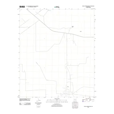
2010 Map of Paduca Breaks NW
USGS Topo · Published 2010About this map
Cotton Place and the surrounding high desert of Lea County are defined by energy extraction and remote transportation networks in this 2010 survey. The landscape is primarily organized around industrial infrastructure, specifically the Double X Oil Field to the northeast and the Paduca Oil Field further south. These fields are connected by a sparse grid of maintained routes, including Orla Rd and County Rd-1. Water is a scarce and vital resource in this arid region, marked here by Jack Tank near the northern boundary. The map illustrates the specialized development of the Permian Basin, where the layout of roads like County Rd-186 and County Rd-31 is dictated more by well access and pipeline corridors than by traditional town centers.
Find a feature on this map
8 named features on this map. Tap any name to fly to it.
Don’t see what you’re looking for? This feature index may not catch every label — zoom into the map to look around manually.
Map Details
Editions of this 2010 Paduca Breaks NW Map
This is the sole edition of this map. No revisions or reprints were ever made.
Other maps of this area

1939 · Nash Draw
USGS Topo · 1:62,500

1943 · Nash Draw
USGS Topo · 1:62,500

1954 · Hobbs
USGS Topo · 1:250,000

1958 · Hobbs
USGS Topo · 1:250,000

1963 · Hat Mesa
USGS Topo · 1:62,500

1968 · Phantom Banks
USGS Topo · 1:24,000
1968 · Big Sinks
USGS Topo · 1:24,000

1973 · Bell Lake
USGS Topo · 1:24,000

1973 · Paduca Breaks NW
USGS Topo · 1:24,000

1973 · Paduca Breaks East
USGS Topo · 1:24,000