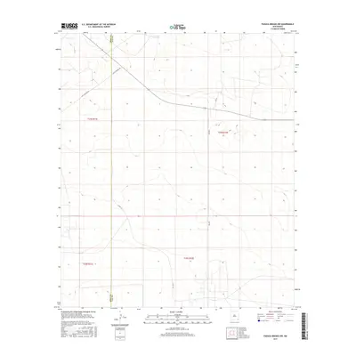
2017 Map of Paduca Breaks NW
USGS Topo · Published 2017About this map
The Eddy Co Lea Co line bisects this high desert landscape in southeastern New Mexico, defining a region where land management and ranching infrastructure predominate. The map illustrates a network of utility and transport corridors, most notably Buck Johnson Rd, which cuts diagonally across the northern townships. Water management in this arid environment is represented by isolated features like Jack Tank, essential markers for local history and land use. The Public Land Survey System grid is meticulously detailed across t24s r31e, t24s r32e, and the southern townships, providing a clear view of the section lines that govern property and lease boundaries in the Permian Basin region. Secondary access routes like Orla Rd and Leo Ln weave through the terrain, indicating the ongoing intersection of ranching heritage and modern resource access.
Find a feature on this map
10 named features on this map. Tap any name to fly to it.
Don’t see what you’re looking for? This feature index may not catch every label — zoom into the map to look around manually.
Map Details
Editions of this 2017 Paduca Breaks NW Map
This is the sole edition of this map. No revisions or reprints were ever made.
Other maps of this area

1939 · Nash Draw
USGS Topo · 1:62,500

1943 · Nash Draw
USGS Topo · 1:62,500

1954 · Hobbs
USGS Topo · 1:250,000

1958 · Hobbs
USGS Topo · 1:250,000

1963 · Hat Mesa
USGS Topo · 1:62,500

1968 · Phantom Banks
USGS Topo · 1:24,000
1968 · Big Sinks
USGS Topo · 1:24,000

1973 · Bell Lake
USGS Topo · 1:24,000

1973 · Paduca Breaks NW
USGS Topo · 1:24,000

1973 · Paduca Breaks East
USGS Topo · 1:24,000