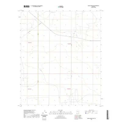
2020 Map of Paduca Breaks NW
USGS Topo · Published 2020About this map
The high plains of the Permian Basin define this landscape along the border of Eddy and Lea counties. In this arid corner of New Mexico, water resources are sparse, marked only by isolated features like Jack Tank in the northern reaches. The survey reveals a sparse network of ranch and energy roads, including Buck Johnson Rd and Buck Jackson Rd, which cut across the geometric grid of the Public Land Survey System. The map documents the vast, open character of the t24s r32e and t25s r32e townships, where long stretches of Orla Rd and Co Rd 1-8 provide the primary transit through the scrubland. This 2020 edition captures the modern infrastructure of an area defined more by its industrial and ranching utility than by permanent settlements.
Find a feature on this map
11 named features on this map. Tap any name to fly to it.
Don’t see what you’re looking for? This feature index may not catch every label — zoom into the map to look around manually.
Map Details
Editions of this 2020 Paduca Breaks NW Map
This is the sole edition of this map. No revisions or reprints were ever made.
Other maps of this area

1939 · Nash Draw
USGS Topo · 1:62,500

1943 · Nash Draw
USGS Topo · 1:62,500

1954 · Hobbs
USGS Topo · 1:250,000

1958 · Hobbs
USGS Topo · 1:250,000

1963 · Hat Mesa
USGS Topo · 1:62,500

1968 · Phantom Banks
USGS Topo · 1:24,000
1968 · Big Sinks
USGS Topo · 1:24,000

1973 · Bell Lake
USGS Topo · 1:24,000

1973 · Paduca Breaks NW
USGS Topo · 1:24,000

1973 · Paduca Breaks East
USGS Topo · 1:24,000