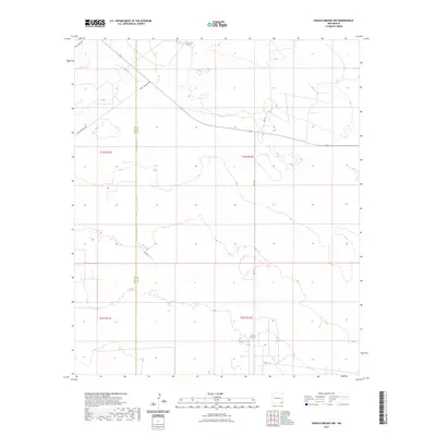
2023 Map of Paduca Breaks NW
USGS Topo · Published 2023About this map
Jack Tank sits near the northern boundary of this high desert landscape, a remote corner of the Eddy and Lea county line in New Mexico. The terrain is characterized by the complex grid of the Public Land Survey System, specifically within t24s r31e, t24s r32e, and the sections to their south. This 2023 survey illustrates a modern infrastructure network of rural access roads and cattle tanks scattered across a sparsely populated region. Crucial local corridors like Leo Ln and Buck Johnson Rd connect the isolated ranching tracts, while Orla Rd and Co Rd 1-8 facilitate movement across the low-lying basins and ridges that define the Pecos Valley periphery. The map provides a precise account of the modern surface features and administrative boundaries in this arid environment.
Find a feature on this map
12 named features on this map. Tap any name to fly to it.
Don’t see what you’re looking for? This feature index may not catch every label — zoom into the map to look around manually.
Map Details
Editions of this 2023 Paduca Breaks NW Map
This is the sole edition of this map. No revisions or reprints were ever made.
Other maps of this area

1939 · Nash Draw
USGS Topo · 1:62,500

1943 · Nash Draw
USGS Topo · 1:62,500

1954 · Hobbs
USGS Topo · 1:250,000

1958 · Hobbs
USGS Topo · 1:250,000

1963 · Hat Mesa
USGS Topo · 1:62,500

1968 · Phantom Banks
USGS Topo · 1:24,000
1968 · Big Sinks
USGS Topo · 1:24,000

1973 · Bell Lake
USGS Topo · 1:24,000

1973 · Paduca Breaks NW
USGS Topo · 1:24,000

1973 · Paduca Breaks East
USGS Topo · 1:24,000