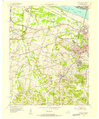
1954 Map of Paducah West
USGS Topo · Published 1955About this map
The Ohio River shoreline and the expansion of western Paducah define this mid-century landscape, where industrial infrastructure meets growing suburban residential areas. The Paducah and Illinois railroad line cuts across the northern terrain, linking the city to the Irvin S Cobb Bridge, while the Illinois Central network services the southern corridor near Lone Oak. Beyond the City Limits, the map reveals a dense network of local institutions essential for genealogical research, including the Mount Kenton Cemetery, Temple Israel Cem, and the Stanley Cem.
Find a feature on this map
70 named features on this map. Tap any name to fly to it.
Don’t see what you’re looking for? This feature index may not catch every label — zoom into the map to look around manually.
Map Details
Editions of this 1954 Paducah West Map
This is the sole edition of this map. No revisions or reprints were ever made.
Other maps of this area

1926 · Paducah
USGS Topo · 1:62,500

1928 · La Center
USGS Topo · 1:62,500

1929 · Paducah
USGS Topo · 1:62,500

1932 · La Center
USGS Topo · 1:62,500

1936 · Melber
USGS Topo · 1:24,000

1936 · Paducah
USGS Topo · 1:24,000

1936 · Symsonia
USGS Topo · 1:24,000

1940 · Paducah
USGS Topo · 1:62,500

1949 · Paducah
USGS Topo · 1:250,000

1950 · Paducah
USGS Topo · 1:250,000