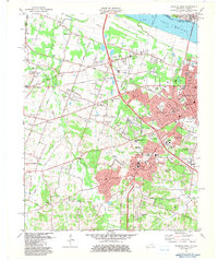
1982 Map of Paducah West
USGS Topo · Published 1983About this map
The Ohio River shoreline and the suburban expansion of western Paducah dominate this 1982 landscape. This survey captures a transitional period for the region, where older rural church-and-cemetery anchors like White Oak Ch and Bumpous Cem meet the modern infrastructure of the Illinois Central Gulf Railroad and major highway interchanges. The development of institutional sites is prominent, including the Paducah Comm College and the West Kentucky State Technical Vocational Sch, illustrating the educational growth of the late twentieth century. South of the main city, the residential clusters of Lone Oak and Hendron show dense settlement patterns, while the outlying western reaches remain characterized by the drainage of Massac Creek and various Gravel Pits, reflecting both the natural hydrology and the extraction industries of McCracken County.
Find a feature on this map
77 named features on this map. Tap any name to fly to it.
Don’t see what you’re looking for? This feature index may not catch every label — zoom into the map to look around manually.
Map Details
Editions of this 1982 Paducah West Map
This is the sole edition of this map. No revisions or reprints were ever made.
Other maps of this area

1926 · Paducah
USGS Topo · 1:62,500

1928 · La Center
USGS Topo · 1:62,500

1929 · Paducah
USGS Topo · 1:62,500

1932 · La Center
USGS Topo · 1:62,500

1936 · Melber
USGS Topo · 1:24,000

1936 · Paducah
USGS Topo · 1:24,000

1936 · Symsonia
USGS Topo · 1:24,000

1940 · Paducah
USGS Topo · 1:62,500

1949 · Paducah
USGS Topo · 1:250,000

1950 · Paducah
USGS Topo · 1:250,000