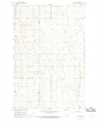
1967 Map of Page SW
USGS Topo · Published 1969About this map
The Maple River meanders across this rural Dakota landscape, defining the eastern drainage of a region marked by extensive wetlands and prairie depressions. Surveyed in the late 1960s, the terrain is characterized by the broad basins of Minnie Lake, Cornell, and Weimer, reflecting the characteristic glacial topography of the Red River Valley hinterlands. A solitary Townhall stands as a central community landmark in a landscape otherwise defined by the grid of section lines and township roads. The boundary between Barnes Co and Cass Co bisects the western half of the sheet, providing a clear view of the jurisdictional divisions that shaped early settlement and local governance in this agricultural heartland.
Find a feature on this map
6 named features on this map. Tap any name to fly to it.
Don’t see what you’re looking for? This feature index may not catch every label — zoom into the map to look around manually.
Map Details
Editions of this 1967 Page SW Map
This is the sole edition of this map. No revisions or reprints were ever made.
Other maps of this area

1897 · Tower
USGS Topo · 1:125,000

1952 · Grand Forks
USGS Topo · 1:250,000

1953 · Fargo
USGS Topo · 1:250,000

1956 · Fargo
USGS Topo · 1:250,000

1956 · Grand Forks
USGS Topo · 1:250,000

1966 · Grand Forks
USGS Topo · 1:250,000

1967 · Tower City
USGS Topo · 1:24,000

1967 · Pillsbury SE
USGS Topo · 1:24,000

1967 · Page SE
USGS Topo · 1:24,000

1967 · Page
USGS Topo · 1:24,000